Terroir
Terroir
The soil under Bordeaux, from the gravel you can hold in your hand to the sea that left its starfish about 30 million years ago. Measured, drawn and explained. Different, not better.
Every bottle from Bordeaux begins as a question about the soil: what lies under the vine, how old it is, how it got there. The answers are written in the gravel of old rivers, in a limestone full of starfish, in a clay that swells with the winter.
The figures come from the public maps of France: BRGM’s geology, IGN’s elevation, INAO’s delimited areas. The words come from the geologists’ notices, the AOC texts and a century and a half of writers on the vineyard. Where they disagree, each side is named.
Ways in
- On the MapSwitch on the Terroir layer and see the rock under every appellation.
- Every appellation39 appellations, each with its soil, its height and a measured section.
- Side by sidePick any 2 and see their soil at one scale.
- 6 real boreholesReal cores from the BRGM notices, lined up from north to south.
- Saint-Émilion and PauillacA written walk across 2 soils: a limestone plateau and a gravel croupe.
- The Sky Over the VinesPick a day since 1842 and see the Bordeaux sky that day, wherever Météo-France holds the record.
The Descent
Read the soil the way you read a well: from the vine at the top down to the rock. Pick a place and scroll. Each layer gets one sentence, with its thickness and its age.
-
graves des terrasses quaternaires
On top lie the sand, gravel and pebbles of the ice age rivers, about 5 m thick.
- Top of the layer
- at the surface
- Thickness
- about 5 m
- Age
- Pleistocene, 2.58 million to 11,700 years ago
Word card graves
gravel
River terraces laid from the end of the Pliocene through the Pleistocene; the Pleistocene runs from 2.58 million to 11,700 years ago (ICS)
Pebbles, stones and sand that the Garonne, the Dordogne and the Isle left behind in the ice ages. The word names a soil first and a wine district second.
All the words of the soilPrinted for the left bank between the estuary and the Tertiary dome. The map names these terraces Günz and Donau-Günz, alpine names with no ICS numbers.
BRGM, Notice explicative de la feuille St-Laurent-et-Benon, Étang-de-Carcans à 1/50 000, 1977, p. 15
-
calcaires oligocènes
In a few places, on under 1% of the appellation, an Oligocene sea limestone shows through.
- Top of the layer
- In patches: not added to the depth.
- Thickness
- not printed; in patches
- Age
- Rupelian, Oligocene, 33.9 to 27.3 million years ago
BRGM BD Charm-50, Gironde (GEO050K_HARM_033, Licence Ouverte 2.0)
-
marnes à Sismondia occitana et à Ostrea bersonensis
Below lie marls from the very end of the Eocene, about 10 m, named for a small fossil sea urchin and an oyster.
- Top of the layer
- about 5 m
- Thickness
- about 10 m
- Age
- end of the Priabonian, Eocene, which closes 33.9 million years ago
Word card marne
marl
A rock of clay and lime mixed together
Féret put the mix at about half clay, half lime, and noted that it crumbles in damp air.
All the words of the soilBRGM, Notice explicative de la feuille Lesparre-Médoc, Forêt-du-Junca à 1/50 000, 1973, p. 15
-
calcaire de Saint-Estèphe
Then comes the calcaire de Saint-Estèphe, a yellowish to whitish clayey limestone in beds of 40 to 50 cm, about 8 m in all.
- Top of the layer
- about 15 m
- Thickness
- about 8 m
- Age
- Priabonian, Eocene, 37.71 to 33.9 million years ago
Word card calcaire de Saint-Estèphe
an older sea limestone
Marine limestone of the late Eocene, Priabonian, 37.71 to 33.9 million years ago (ICS)
A limestone from a sea older than the starfish one. Across the estuary, on the Montendre sheet, it shows as a hard, yellowish limestone in beds 10 to 40 cm thick.
All the words of the soilNamed after the neighboring commune, where it was defined.
BRGM, Notice explicative de la feuille Lesparre-Médoc, Forêt-du-Junca à 1/50 000, 1973, p. 14
-
argiles de l’Éocène supérieur basal
A clay layer of about 4 m follows, and in places it is missing.
- Top of the layer
- about 23 m
- Thickness
- about 4 m on average; missing in places
- Age
- base of the late Eocene, as the notice prints it; no stage is named
BRGM, Notice explicative de la feuille Lesparre-Médoc, Forêt-du-Junca à 1/50 000, 1973, p. 11
-
calcaires et sables de l’Éocène moyen
Then the middle Eocene: sandy limestones above and, at the base, sand and sandstone that pass 75 m around Pauillac.
- Top of the layer
- about 23 to 27 m
- Thickness
- its sandy base alone passes 75 m near Pauillac
- Age
- middle Eocene; its top is Lutetian, 48.07 to 41.03 million years ago
BRGM, Notice explicative de la feuille Lesparre-Médoc, Forêt-du-Junca à 1/50 000, 1973, pp. 11, 38, 39
-
sables et grès de l’Éocène inférieur
Sands, sandstones and sandy limestones of the early Eocene follow, from 100 m thick in the east to more than 200 m in the west.
- Top of the layer
- at least 98 m
- Thickness
- 100 m in the east to more than 200 m in the west
- Age
- early Eocene, Ypresian, 56.0 to 48.07 million years ago
BRGM, Notice explicative de la feuille Lesparre-Médoc, Forêt-du-Junca à 1/50 000, 1973, pp. 10, 39
-
marnes et argiles du Crétacé supérieur
At the foot of this column, marls and clays of the Late Cretaceous make a watertight cover 400 m thick at Pauillac.
- Top of the layer
- at least 198 m
- Thickness
- 400 m at Pauillac
- Age
- Late Cretaceous, older than 66.0 million years
BRGM, Notice explicative de la feuille Lesparre-Médoc, Forêt-du-Junca à 1/50 000, 1973, p. 41
The notices go deeper; this column stops here, at least 598 m below the vine.
Download this column as a card
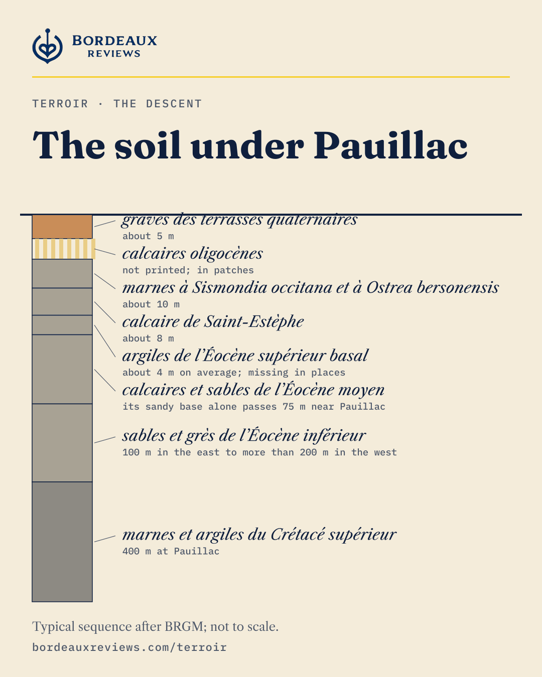
Typical sequence after BRGM notices 0754 (Lesparre-Médoc) and 0778 (St-Laurent-et-Benon), with the shares of BD Charm-50. The thicknesses are printed for the Pauillac area and its neighbors, not measured at one spot. Not to scale: thick layers are shortened, and the depth adds up the printed thicknesses.
-
colluvions limoneuses
A thin skin of silt washed down from the slopes, a few decimeters to 1 m, covers the rock; the map leaves it off.
- Top of the layer
- at the surface
- Thickness
- a few decimeters to 1 m
- Age
- not dated by the notice
BRGM, Notice explicative de la feuille Libourne à 1/50 000, 1995, p. 8
-
marnes bleues et blanches à nodules calcaires
Here and there, a few meters of blue and white marl survive on top, the last of a layer that lies mostly farther south.
- Top of the layer
- In patches: not added to the depth.
- Thickness
- a few meters; only in outliers
- Age
- Rupelian, Oligocene, 33.9 to 27.3 million years ago
Word card marne
marl
A rock of clay and lime mixed together
Féret put the mix at about half clay, half lime, and noted that it crumbles in damp air.
All the words of the soilBRGM, Notice explicative de la feuille Libourne à 1/50 000, 1995, p. 21
-
calcaire à astéries
Then the calcaire à astéries, the starfish limestone, 10 to 15 m thick: the rock of the plateau.
- Top of the layer
- within 1 m of the surface
- Thickness
- 10 to 15 m
- Age
- Rupelian, Oligocene, 33.9 to 27.3 million years ago
Word card calcaire à astéries
starfish limestone
Marine limestone of the Rupelian, Oligocene, 33.9 to 27.3 million years ago (ICS)
Named by Delbos in 1847 for the starfish bones packed inside it. It caps the plateau of Saint-Émilion, 10 to 15 m thick, and old underground quarries in it gave the stone that built the town.
All the words of the soilBRGM, Notice explicative de la feuille Libourne à 1/50 000, 1995, p. 23
-
marnes vertes et faluns
At its foot lie green marls and shelly sands, 5 to 7 m, left where rivers met the sea.
- Top of the layer
- about 10 to 16 m
- Thickness
- 5 to 7 m
- Age
- Rupelian, Oligocene, 33.9 to 27.3 million years ago
Word card falun
shell sand
A sea deposit packed with shells and shell fragments, in sand or marl; its age depends on the formation. In the Gironde the notices print faluns of the Oligocene and of the early Miocene (Aquitanian and Burdigalian, 23.04 to 15.98 million years ago, ICS)
When the sea came back early in the Miocene it left beds of broken shells, often green from grains of glauconite. The 1973 notice, written before today's chart, put the start at about 25 million years.
All the words of the soilBRGM, Notice explicative de la feuille Libourne à 1/50 000, 1995, p. 22
-
argiles et calcaires de Castillon
Below them, the calcaire de Castillon: lake limestone and clay, 10 to 12 m.
- Top of the layer
- about 15 to 23 m
- Thickness
- 10 to 12 m
- Age
- base of the Rupelian, Oligocene, from 33.9 million years ago
Word card calcaire de Castillon
lake limestone and clay
Lake deposits at the base of the Rupelian, Oligocene, from 33.9 million years ago (ICS)
Green to whitish clays and limestones, 10 to 12 m thick, left by a lake. Matheron gave the name in 1867.
All the words of the soilBRGM, Notice explicative de la feuille Libourne à 1/50 000, 1995, p. 21
-
argiles vertes carbonatées et sables feldspathiques
Then about 15 m of green limy clays and feldspar sands.
- Top of the layer
- about 25 to 35 m
- Thickness
- about 15 m
- Age
- early Oligocene, from 33.9 million years ago
BRGM, Notice explicative de la feuille Libourne à 1/50 000, 1995, p. 20
-
molasses du Fronsadais, partie supérieure
The molasse du Fronsadais begins: gray sands and limy clays laid down by old rivers, 15 to 20 m.
- Top of the layer
- about 40 to 50 m
- Thickness
- 15 to 20 m
- Age
- early Oligocene, from 33.9 million years ago
Word card molasse du Fronsadais
old river and lake clays and sands
Continental deposits from the late Eocene (Priabonian, from 37.71 million years ago) to the base of the Oligocene (from 33.9, ICS)
Soft beds laid by rivers and lakes on land, under the starfish limestone. BRGM calls it a local term “hallowed by use”. Some modern writers call it a soft limestone; the geologists' maps describe clays and sands.
All the words of the soilBRGM, Notice explicative de la feuille Libourne à 1/50 000, 1995, p. 19
-
molasses du Fronsadais, parties inférieure et moyenne
Its lower part, yellowish sandy clays of the late Eocene, adds 20 to 25 m.
- Top of the layer
- about 55 to 70 m
- Thickness
- 20 to 25 m
- Age
- Priabonian, Eocene, 37.71 to 33.9 million years ago
Word card molasse du Fronsadais
old river and lake clays and sands
Continental deposits from the late Eocene (Priabonian, from 37.71 million years ago) to the base of the Oligocene (from 33.9, ICS)
Soft beds laid by rivers and lakes on land, under the starfish limestone. BRGM calls it a local term “hallowed by use”. Some modern writers call it a soft limestone; the geologists' maps describe clays and sands.
All the words of the soilBRGM, Notice explicative de la feuille Libourne à 1/50 000, 1995, pp. 18, 19
-
argiles à Palaeotherium et molasses inférieures
At the foot of this column lie the argiles à Palaeotherium, named for an extinct relative of the horse: many-colored clays with sandy channels, 40 to 100 m.
- Top of the layer
- about 75 to 95 m
- Thickness
- 40 to 100 m
- Age
- middle to late Eocene, as the notice prints it; no stage is named
BRGM, Notice explicative de la feuille Libourne à 1/50 000, 1995, p. 17
The notices go deeper; this column stops here, about 115 to 195 m below the vine.
Download this column as a card
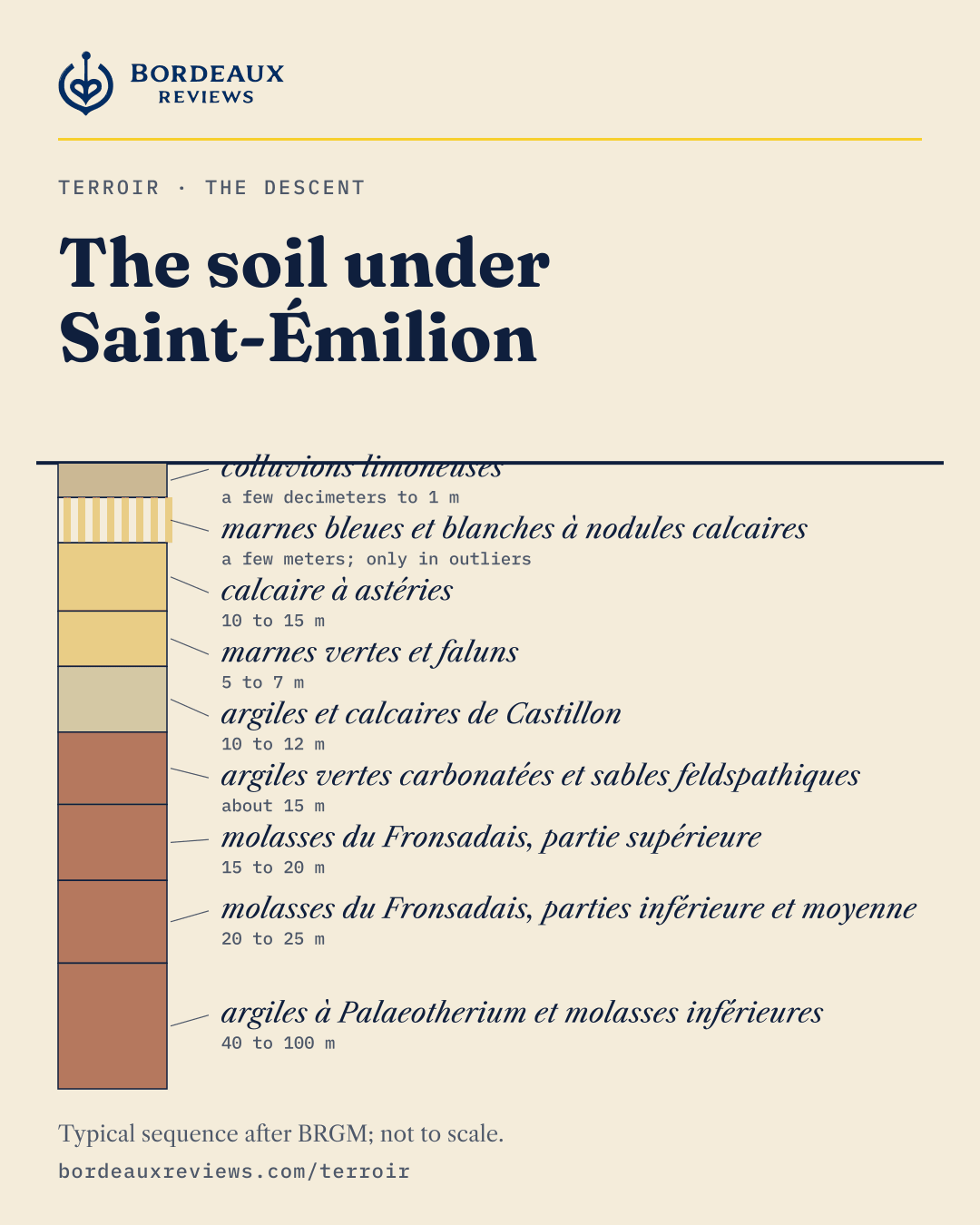
Typical sequence of the limestone plateau after BRGM notice 0804 (Libourne), with the shares of BD Charm-50. The thicknesses are the notice’s averages, not measured at one spot. Not to scale: thick layers are shortened, and the depth adds up the printed thicknesses.
-
colluvions limoneuses
A thin skin of silt, a few decimeters to 1 m, lies over the gravel; the map leaves it off.
- Top of the layer
- at the surface
- Thickness
- a few decimeters to 1 m
- Age
- not dated by the notice
BRGM, Notice explicative de la feuille Libourne à 1/50 000, 1995, p. 8
-
terrasses de l’Isle et de la Dordogne
Then the gravel of the Isle and Dordogne terraces: sand, gravel and pebbles, 5 to 10 m on the lower terrace and 10 to 15 m on the higher one.
- Top of the layer
- within 1 m of the surface
- Thickness
- 5 to 10 m on the lower terrace, 10 to 15 m on the higher
- Age
- Pleistocene, 2.58 million to 11,700 years ago
Word card terrasse
river terrace
A step of old river deposits left high as the river cut down
Stairs of gravel along the rivers, the oldest highest. At Margaux they now stand as hills between 6 and 33 m.
All the words of the soilThe notice calls the terraces Mindel and Würm; the harmonized map calls them Günz and Riss. Both are kept as printed.
BRGM, Notice explicative de la feuille Libourne à 1/50 000, 1995, pp. 25, 26, 32
-
molasses du Fronsadais, partie supérieure
Under the gravel, and beside it on a quarter of the appellation, lies the molasse du Fronsadais: gray sands and limy clays, 15 to 20 m.
- Top of the layer
- about 5 to 16 m
- Thickness
- 15 to 20 m
- Age
- early Oligocene, from 33.9 million years ago
Word card molasse du Fronsadais
old river and lake clays and sands
Continental deposits from the late Eocene (Priabonian, from 37.71 million years ago) to the base of the Oligocene (from 33.9, ICS)
Soft beds laid by rivers and lakes on land, under the starfish limestone. BRGM calls it a local term “hallowed by use”. Some modern writers call it a soft limestone; the geologists' maps describe clays and sands.
All the words of the soilBRGM, Notice explicative de la feuille Libourne à 1/50 000, 1995, p. 19
-
molasses du Fronsadais, parties inférieure et moyenne
Its lower part, yellowish sandy clays of the late Eocene, adds 20 to 25 m.
- Top of the layer
- about 20 to 36 m
- Thickness
- 20 to 25 m
- Age
- Priabonian, Eocene, 37.71 to 33.9 million years ago
Word card molasse du Fronsadais
old river and lake clays and sands
Continental deposits from the late Eocene (Priabonian, from 37.71 million years ago) to the base of the Oligocene (from 33.9, ICS)
Soft beds laid by rivers and lakes on land, under the starfish limestone. BRGM calls it a local term “hallowed by use”. Some modern writers call it a soft limestone; the geologists' maps describe clays and sands.
All the words of the soilBRGM, Notice explicative de la feuille Libourne à 1/50 000, 1995, p. 18
-
argiles à Palaeotherium et molasses inférieures
At the foot of this column lie the argiles à Palaeotherium, named for an extinct relative of the horse: many-colored clays with sandy channels, 40 to 100 m.
- Top of the layer
- about 40 to 61 m
- Thickness
- 40 to 100 m
- Age
- middle to late Eocene, as the notice prints it; no stage is named
BRGM, Notice explicative de la feuille Libourne à 1/50 000, 1995, p. 17
The notices go deeper; this column stops here, about 80 to 161 m below the vine.
Download this column as a card
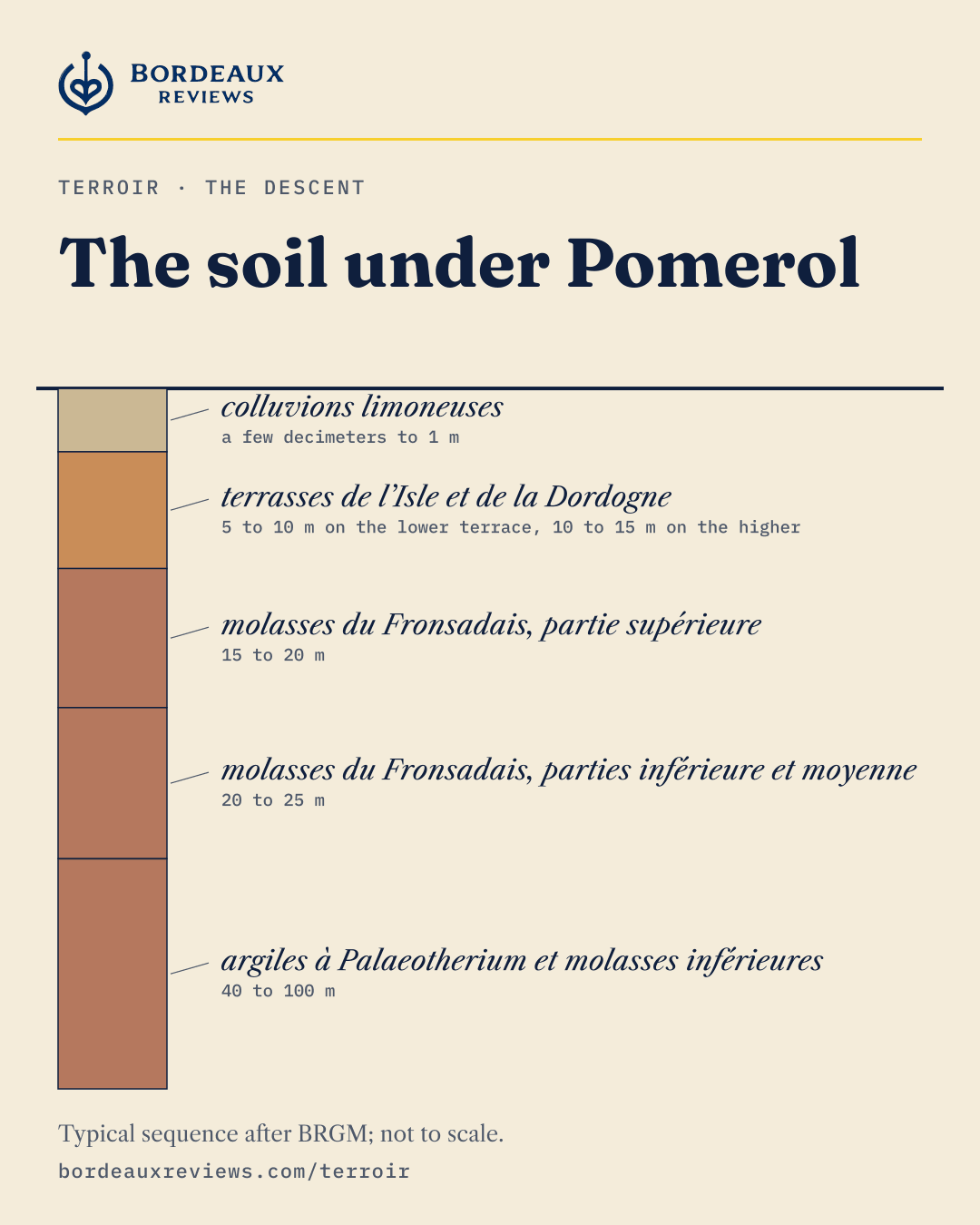
Typical sequence after BRGM notice 0804 (Libourne), with the shares of BD Charm-50. The thicknesses are the notice’s averages, not measured at one spot. Not to scale: thick layers are shortened, and the depth adds up the printed thicknesses.
Sources: BRGM, Notice explicative de la feuille Lesparre-Médoc, Forêt-du-Junca à 1/50 000, 1973; BRGM, Notice explicative de la feuille St-Laurent-et-Benon, Étang-de-Carcans à 1/50 000, 1977; BRGM, Notice explicative de la feuille Libourne à 1/50 000, 1995; BRGM BD Charm-50, Gironde (GEO050K_HARM_033, Licence Ouverte 2.0); International Commission on Stratigraphy, International Chronostratigraphic Chart, v2024/12.
6 real boreholes
The Descent shows a typical sequence. These are real holes, with the logs printed in the BRGM notices, from north to south. Tap one to read its core.
- Colors of the ICS chart for each age
- Quaternary
- Oligocene
- upper Eocene
- middle Eocene
- lower Eocene
- Eocene
- Late Cretaceous
- Cretaceous
- not identified
Saint-Girons-d’Aiguevives, borehole 779-3-3
75.2 m deep · On the Blaye Côtes de Bordeaux section
- 0 to 8 minconnunot identified
- 8 to 33.4 mSannoisien et Éocène supérieurSannoisian and upper Eocene
- 33.4 to 63.5 mÉocène supérieurupper Eocene
- 63.5 to 75.2 mCalcaire grossier de BlayeBlaye coarse limestone
Lamarque, borehole 779-1-6
177.7 m deep · On the Haut-Médoc section
- 0 to 6.2 mQuaternaireQuaternary
- 6.2 to 136.8 mÉocène moyenmiddle Eocene
- 136.8 to 156.4 mÉocène inférieurlower Eocene
- 156.4 to 177.7 mSénonien supérieurupper Senonian
Cantenac, borehole 779-5-9
130.2 m deep · On the Margaux section
- 0 to 9.6 mQuaternaireQuaternary
- 9.6 to 32.6 mÉocène supérieurupper Eocene
- 32.6 to 130.2 mÉocène moyenmiddle Eocene
Cadillac, borehole 852-1-1
202 m deep · On the Loupiac section
- 0 to 5.4 mQuaternaireQuaternary
- 5.4 to 71 mOligocèneOligocene
- 71 to 202 mÉocèneEocene
Cérons, borehole 852-1-9
354 m deep · On the Cérons section
- 0 to 2.3 mQuaternaireQuaternary
- 2.3 to 69 mOligocèneOligocene
- 69 to 333 mÉocèneEocene
- 333 to 354 mCrétacéCretaceous
Toulenne, borehole 852-2-11
152.2 m deep · On the Sauternes section
- 0 to 2.5 mQuaternaireQuaternary
- 2.5 to 60 mOligocèneOligocene
- 60 to 152.2 mÉocèneEocene
In the 2 Médoc cores, the Eocene starts right under the Quaternary. In the 3 cores south of Bordeaux, about 58 to 67 m of Oligocene lie between the two.
The logs name ages, not rocks. The first is on the right bank of the estuary, the next 2 in the Médoc, the last 3 along the Garonne south of Bordeaux. Cadillac lies 894 m from the Loupiac line. One scale for all 6.
BRGM, Notice explicative de la feuille Blaye-et-Ste-Luce à 1/50 000, 1977, p. 42; BRGM, Notice explicative de la feuille Langon à 1/50 000, 1978, pp. 24 and 25; ages: ICS, v2024/12.
How high is a croupe?
People picture hills. Here is a croupe near Pauillac, measured every 5 meters by IGN. At 1×, you see it as it is: the land rises 17 m over 550 m, a slope of about 3%. The sections on this site stretch heights 20 times so the eye can read them. Slide, and watch the hills appear.
17 m is the height of a 5 or 6 story building; 550 m is about 5 football fields end to end.
The jalles and the esteys cut the gravel into croupes in the ice ages, in the words of the Médoc AOC text. People finished the work on the palus. By his edict of 1599 on the drying of marshes, Henri IV handed the task to Humphrey Bradley, an engineer from Brabant, and his partners; one of them, Conrad Gaussen, signed for the marshes of Guyenne from 1599. Dutch names fill the list of those who backed the draining of the Lesparre marshes.
INAO, cahier des charges Médoc; de Dienne, Histoire du desséchement des lacs et marais en France avant 1789, 1891; Malvezin, Histoire du commerce de Bordeaux, volume II, 1892.
Deep time in a barrique
Pour 50 million years into a barrique of 225 liters, from the bottom up. Each liter holds about 222,000 years. Drag the level, or tap the barrel, and see what soil was being laid down at that liter.
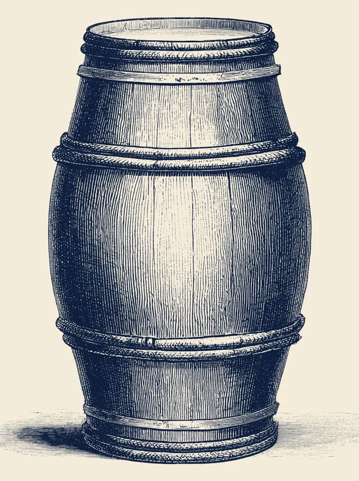
Liter 72 to 102 of 225
33.9 to 27.3 million years ago: Rupelian, Oligocene
On the map of the appellations: Starfish limestone and marine marls.
Ages: the ICS International Chronostratigraphic Chart, v2024/12. Families: the ages BRGM’s harmonized map (BD Charm-50) prints for the soil inside the appellations, matched to the ICS stages. The old Alpine names (Günz, Mindel, Riss, Würm) and the northern European stages the notices use have no ICS numbers; all fall within the Pleistocene. Slope wash and cover carry no printed age and are left out.
Press the clay
On the Pomerol plateau, in places, the gravel thins and, at about 50 cm on average, gives way to a heavy, blue-gray clay. It breathes with the seasons.
Summer: the clay shrinks and cracks. Fine roots move into the cracks.Winter: the clay swells, the cracks close, and those rootlets die, crushed.
This is the plateau, in places. Across most of Pomerol the gravel lies at the surface or just below. And the age of that clay is argued: Oligocene for the geologists of the Libourne map, of the ice ages for a university study, of open origin for 2 soil studies. And the “crasse de fer”?
The water table through the year
Under the vines, the soil holds water. In winter the rain fills it and the water table rises; through spring and summer the vines drink, the sun dries the soil, and it sinks. 2 wells inside the delimited vineyard have been read for decades: one in the gravel at Macau, one in the starfish limestone at Le Taillan-Médoc. Turn the year.
In April, the water stands 3.2 m down at Macau and 5.9 m down at Le Taillan-Médoc (medians).
- Well at Macau, 2007 to 2026. At the surface: Ice age river terraces: sand, gravel, pebbles
- Well at Le Taillan-Médoc, 1978 to 2026. At the surface: Starfish limestone and marine marls
- 8 years in 10
- roots, after Seguin (1975)
In the Médoc gravel, Gérard Seguin found in 1975 that until early August the fine roots grow down into the soil the sinking water table leaves behind, and drink the water it leaves there. In that gravel, roots reach as far as 5 m, often stopped by the water table itself.
Where the water stays high, it sets a floor: in a sandy soil of the Isle valley, a 1978 study measured the water table between 50 cm below the surface in winter and 2 m in summer. It limits how deep the roots go and likely helps feed the vine.
Hub’Eau, ADES piezometry: wells BSS001XWGD (Macau, works 4.9 m deep) and BSS001XZUD (Le Taillan-Médoc, works 12.1 m deep). Monthly means of measures qualified as correct and read in the field only; for each month, the median over all years and the band where 8 years in 10 fall. Depth below the well’s reference mark. Roots drawn schematically. Seguin, Alimentation en eau de la vigne et composition chimique des moûts dans les grands crus du Médoc, 1975; Guilloux-Benatier, Duteau, Seguin, Connaissance de la Vigne et du Vin 12(3), 1978.
The palus, then and now
Along the estuary and the rivers lies the palus: marsh land, the youngest clay of all, which people drained into fields. Drag the lens over IGN’s aerial photo to see the same place on the État-major map, surveyed between 1820 and 1866, or in the aerial photos of 1950 to 1965.
Outside the lens: IGN’s aerial photo (BD ORTHO, update date in the credits). Drag the lens, or tap a spot. With a keyboard, use the arrow keys. A window about 4 km across.
Maps and photos: IGN, Institut national de l’information géographique et forestière, through the Géoplateforme (data.geopf.fr), under the Licence Ouverte. Updated: SCAN EM 40k on December 8, 2025; BD ORTHO Historique on October 15, 2026; BD ORTHO on October 7, 2026. The État-major map stops at zoom 15 and is shown enlarged. Palus: BRGM, notice Lesparre-Médoc, 1973; BRGM, notice Podensac, 1996.
Words of the soil
Every hard word arrives in 3 rungs: the plain word, the local word, the science word. Climb only as far as you like.
-
gravel
graves
River terraces laid from the end of the Pliocene through the Pleistocene; the Pleistocene runs from 2.58 million to 11,700 years ago (ICS)
Pebbles, stones and sand that the Garonne, the Dordogne and the Isle left behind in the ice ages. The word names a soil first and a wine district second.
Sources: INAO, cahier des charges Graves; INAO, cahier des charges Margaux; Jullien, Topographie de tous les vignobles connus, 1816
-
a low gravel rise
croupe
A remnant of a river terrace, left standing between valleys cut in the cold periods of the Pleistocene
The long, rounded backs of gravel between the streams of the Médoc. The Médoc cahier also gives the local word “cos”. Measured near Pauillac, one rises 17 m over 550 m.
Sources: INAO, cahier des charges Médoc; BRGM, notice Lesparre-Médoc, 1973; IGN RGE ALTI 5 m, line T1
-
a stream
jalle
A small stream that drains the gravel toward the estuary
The Médoc's word for its streams. The jalles and the esteys cut the gravel into croupes, in the words of the AOC text.
Sources: INAO, cahier des charges Saint-Estèphe; Féret, Statistique générale de la Gironde, 1874
-
a tidal creek
estey
A small tributary of the Garonne or the Dordogne that rises and falls with the tides of the estuary
A Gascon word. Its water runs both ways, with the tide that comes up the estuary twice a day.
Sources: Lavaud, La flotte communale au service de l'effort de guerre, 2013
-
a drainage ditch
craste
A man-made ditch that carries water off flat, wet land
Dug to dry the landes. A traveler in 1812 already heard the word “in the language of the country”.
Sources: BRGM, notice Saint-Vivien-de-Médoc, 1972; Saint-Amans, Voyage agricole, botanique et pittoresque, 1812
-
river marsh land
palus
Clayey alluvium of the Holocene, laid down as the sea rose after the last ice age (the Flandrian rise), from 11,700 years ago (ICS)
The youngest soil along the rivers: rich, heavy, often gray or bluish clay. The BRGM glossary calls it marsh land; people drained it into fields.
Sources: BRGM, notice Lesparre-Médoc, 1973; BRGM, notice Podensac, 1996; INAO, cahier des charges Bordeaux
-
starfish limestone
calcaire à astéries
Marine limestone of the Rupelian, Oligocene, 33.9 to 27.3 million years ago (ICS)
Named by Delbos in 1847 for the starfish bones packed inside it. It caps the plateau of Saint-Émilion, 10 to 15 m thick, and old underground quarries in it gave the stone that built the town.
Sources: BRGM, notice Langon, 1978; BRGM, notice Libourne, 1995; BRGM, notice Blaye, 1977
-
the same starfish limestone, by its older name
calcaire de Bourg
Rupelian, Oligocene, 33.9 to 27.3 million years ago (ICS)
The Blayais name for the rock, until a commission reporting on the cuttings of the Bordeaux to Paris railway named it calcaire à astéries in 1847.
Sources: BRGM, notice Blaye, 1977; Des Moulins and others, Rapport de la Commission, 1847
-
old river and lake clays and sands
molasse du Fronsadais
Continental deposits from the late Eocene (Priabonian, from 37.71 million years ago) to the base of the Oligocene (from 33.9, ICS)
Soft beds laid by rivers and lakes on land, under the starfish limestone. BRGM calls it a local term “hallowed by use”. Some modern writers call it a soft limestone; the geologists' maps describe clays and sands.
Sources: BRGM, notice Lesparre-Médoc, 1973; Gourdon-Platel, Caractères physiques des terroirs du vignoble libournais, 1978
-
lake limestone and clay
calcaire de Castillon
Lake deposits at the base of the Rupelian, Oligocene, from 33.9 million years ago (ICS)
Green to whitish clays and limestones, 10 to 12 m thick, left by a lake. Matheron gave the name in 1867.
Sources: BRGM, notice Libourne, 1995; BRGM, notice Blaye, 1977
-
an older sea limestone
calcaire de Saint-Estèphe
Marine limestone of the late Eocene, Priabonian, 37.71 to 33.9 million years ago (ICS)
A limestone from a sea older than the starfish one. Across the estuary, on the Montendre sheet, it shows as a hard, yellowish limestone in beds 10 to 40 cm thick.
Sources: BRGM, notice Lesparre-Médoc, 1973; BRGM, notice Montendre, 1970
-
shell sand
falun
A sea deposit packed with shells and shell fragments, in sand or marl; its age depends on the formation. In the Gironde the notices print faluns of the Oligocene and of the early Miocene (Aquitanian and Burdigalian, 23.04 to 15.98 million years ago, ICS)
When the sea came back early in the Miocene it left beds of broken shells, often green from grains of glauconite. The 1973 notice, written before today's chart, put the start at about 25 million years.
Sources: BRGM, notice Lesparre-Médoc, 1973; Linder, Des dépôts lacustres du vallon de Saucats, 1869; BRGM, notice Libourne, 1995
-
iron pan
alios
A hardened soil layer where humus or iron has gathered and cemented the sand
A dark, sandstone-like crust under the landes and some gravels. The AOC text calls it sand bound by iron; the BRGM glossary, a hardened layer of humus or iron. Roots and water stop at it.
Sources: BRGM, notice Saint-Vivien-de-Médoc, 1972; INAO, cahier des charges Graves; Linder, Étude sur les terrains de transport, 1866
-
“iron dross”, a local name
crasse de fer
No single meaning: the sources give 3
A word of the Libournais, and the sources do not agree on what it names.
The sources disagree
- The Pomerol AOC text: iron oxides in the subsoil.
- Cocks and Féret, from 1868: a hard, iron-rich soil, also called mâchefer.
- A 1997 soil survey of Pomerol: iron and manganese concretions in the deep sandy soils of the south and west.
- The BRGM Libourne notice never uses the term.
Sources: INAO, cahier des charges Pomerol; Cocks and Féret, Bordeaux et ses vins, 1868; Mérouge, Arrouays, Seguin, Journal International des Sciences de la Vigne et du Vin 31(4), 1997; BRGM, notice Libourne, 1995
-
the Libournais name for iron pan
mâchefer
Banks of alios, in the soil sense
In industry the word means clinker. In the soils of the Libournais, Féret wrote, it is what people call the alios banks. All 3 French passages found are his.
Sources: Féret, Saint-Émilion et ses vins, 1908; Féret, Les vins de l'arrondissement de Libourne, 1897
-
pale silty soil
boulbène
A pale, acid, silty soil; how it got there is argued
Fine, ash-colored soil on the plateaus between the rivers.
The sources disagree
- The AOC Bordeaux and Entre-deux-Mers texts: silts brought by the wind.
- The BRGM Libourne notice: wind or floods, still disputed.
- Franck, 1853: clay mixed with very fine rounded sand, without lime.
- The English Cocks and Féret calls it soft in 1883 and hard in 1899.
Sources: INAO, cahier des charges Entre-deux-Mers; BRGM, notice Podensac, 1996; BRGM, notice Libourne, 1995; Franck, Traité sur les vins du Médoc, 1853
-
heavy clay soil
terrefort
Deep brown soils, clayey or clayey-sandy, formed on molasses and marls
Strong soil, hard to work. BRGM calls these soils calcareous or calcic; the Saint-Macaire AOC text calls them decarbonated but calcic.
Sources: BRGM, notice Sainte-Foy-la-Grande, 1994; INAO, cahier des charges Côtes de Bordeaux-Saint-Macaire; Cocks, Bordeaux, ses environs et ses vins, 1850
-
gravelly red clay
argile à graviers
A very high river sheet of sand and gravel in a reddened clay; its age is argued
It sits on the hilltops of the Entre-deux-Mers, a few meters to 15 m thick. The BRGM Bordeaux notice of 1977 calls it Pliocene; the Pessac notice of 1978 moves it to the base of the Pleistocene.
Sources: BRGM, notice Libourne, 1995; BRGM, notice Pessac, 1978; BRGM, notice Bordeaux, 1977
-
Landes sand
sables des Landes
Wind-blown sand of the Quaternary; the BRGM notices date it to the Late Glacial
White to reddish quartz sand that the wind spread west of the croupes and between them. Writers of the 1860s to 1880s thought it Tertiary or Pliocene; the BRGM notices place it at the end of the last ice age.
Sources: BRGM, notice Pessac, 1978; INAO, cahier des charges Saint-Estèphe; Linder, Étude sur les terrains de transport, 1866
-
swelling clay
smectite
A family of clay minerals that take in water and swell
In some Libournais deposits it makes up 60 to 70% of the clay. It holds a great deal of water, yet a 2008 study found that little of it is available to the vine.
Sources: BRGM, notice Libourne, 1995; INAO, cahier des charges Pomerol; van Leeuwen and others, Alimentation hydrique de la vigne et qualité des raisins, 2008
-
river terrace
terrasse
A step of old river deposits left high as the river cut down
Stairs of gravel along the rivers, the oldest highest. At Margaux they now stand as hills between 6 and 33 m.
Sources: Linder, Étude sur les terrains de transport, 1866; INAO, cahier des charges Margaux
-
hillside
coteau
A slope cut into Tertiary rock, below a plateau
On the Côtes de Bordeaux the steep face drops about 30 m in some places and more than 70 m in others, with a plateau on top and the river plain below.
Sources: INAO, cahier des charges Côtes de Bordeaux; Franck, Traité sur les vins du Médoc, 1853
-
table land
plateau
At Saint-Émilion, the flat top of the starfish limestone, up to 100 m
Rivers ate into its edge and left steep combes, where the villages shelter. The Dordogne lies to the south, the Barbanne to the north.
Sources: INAO, cahier des charges Saint-Émilion; Roudié, 1968
-
river-rolled pebbles
cailloux roulés
Pebbles rounded by transport in water, mostly quartz
Pieces of the Pyrenees carried down the Garonne, and of the Massif Central down the Dordogne and the Isle, worn smooth on the way.
Sources: Billaudel, Essai sur le gisement des cailloux roulés, 1830; Des Moulins, Étude sur les cailloux roulés de la Dordogne, 1866
-
marl
marne
A rock of clay and lime mixed together
Féret put the mix at about half clay, half lime, and noted that it crumbles in damp air.
Sources: Féret, Statistique générale de la Gironde, 1878
-
heath
lande
Flat, sandy, poorly drained land under heather and pine
Wet in winter and burnt in summer, as an old text put it. West of the croupes the vines give way to it.
Sources: Franck, Traité sur les vins du Médoc, 1853; Joubert and others, Culture de la vigne dans le Médoc, 1842
The 39 appellations
- Barsac
- Blaye Côtes de Bordeaux
- Bordeaux AOC
- Bordeaux Supérieur
- Cadillac Côtes de Bordeaux
- Canon-Fronsac
- Castillon Côtes de Bordeaux
- Cérons
- Côtes de Bordeaux
- Côtes de Bordeaux-Saint-Macaire
- Côtes de Bourg
- Crémant de Bordeaux
- Entre-deux-Mers
- Francs Côtes de Bordeaux
- Fronsac
- Graves
- Graves de Vayres
- Graves Supérieures
- Haut-Benauge
- Haut-Médoc
- Lalande-de-Pomerol
- Listrac-Médoc
- Loupiac
- Lussac-Saint-Émilion
- Margaux
- Médoc
- Montagne-Saint-Émilion
- Moulis
- Pauillac
- Pessac-Léognan
- Pomerol
- Premières Côtes de Bordeaux
- Puisseguin-Saint-Émilion
- Saint-Émilion
- Saint-Estèphe
- Saint-Georges-Saint-Émilion
- Saint-Julien
- Sainte-Croix-du-Mont
- Sauternes
Sources
- BRGM, harmonized geological map of the Gironde at 1:50,000 (BD Charm-50) and the sheet notices (Licence Ouverte 2.0)
- IGN, RGE ALTI 5 m, Gironde, edition 2021-04-19 (Licence Ouverte)
- INAO, digitized parcel delimitation of 2026-10-12; the AOC cahiers des charges
- International Commission on Stratigraphy, International Chronostratigraphic Chart v2024/12
- Mérouge, Arrouays, Seguin, Journal International des Sciences de la Vigne et du Vin 31(4), 1997; Mérouge, Seguin, Arrouays, same journal 32(2), 1998
- Van Leeuwen, Baudet, Duteau, Seguin, Wilbert, Connaissance de la Vigne et du Vin 23(3), 1989
Test yourself on Bordeaux · Found an error? Corrections