Side by side
Terroir
Saint-Émilion and Pauillac, side by side
One appellation stands on many soils, from limestone at the top to river gravel at the bottom. The other stands on gravel almost from end to end. Different, not better.
The geology, measured
I laid each appellation’s delimited area, the land where its vines may be planted, over BRGM’s geological map of the Gironde, and measured how much of it lies on each kind of soil. The families come from the map’s own legend, by age and rock, listed in the legend’s order, youngest first.
- Slope wash and cover12.6%
- River and estuary deposits of today3.0%
- Ice age river terraces: sand, gravel, pebbles43.7%
- Starfish limestone and marine marls12.8%
- Lake limestones and clays2.3%
- Molasses: sands and clays of old rivers and lakes25.6%
- Slope wash and cover8.8%
- River and estuary deposits of today0.7%
- Ice age river terraces: sand, gravel, pebbles88.0%
- Landes sand and the oldest river deposits1.2%
- Starfish limestone and marine marls0.7%
- Lake limestones and clays0.1%
- Older sea limestones and marls0.7%
Shares of the delimited area. Because of rounding, they may not add to exactly 100.
Saint-Émilion: from the plateau to the Dordogne
- Plateau: starfish limestone: 62 to 86 m, from 0.0 to 1.4 km
- Côte: molasses, with the lake limestone: 28 to 61 m, from 1.4 to 2.4 km
- Foot of the slope: slope wash and cover: 21 to 27 m, from 2.4 to 2.9 km
- Terraces of sand and gravel, in 3 steps: 8 to 21 m, from 2.9 to 5.5 km
- Low land by the river: recent deposits and the palus: 1 to 8 m, from 5.5 to 6.9 km
Colors: the geology at the surface: Starfish limestone and marine marlsSlope wash and coverMolasses: sands and clays of old rivers and lakesLake limestones and claysIce age river terraces: sand, gravel, pebblesRiver and estuary deposits of today
Saint-Émilion is a staircase. At the top, the plateau around the town is capped by the starfish limestone (calcaire à astéries), laid down in a shallow sea about 34 to 27 million years ago. On the Libourne map sheet it averages 10 to 15 meters thick. It covers 12.8% of the appellation.
Under the limestone lie the molasses: sands and clays that rivers and lakes left before the sea came. The côtes, the slopes below the plateau, are cut into them, and they cover 25.6%. Toward Castillon a hard lake limestone shows through, 2.3%.
Below the slopes the land flattens into terraces of sand and gravel, which the Dordogne and the Isle laid down in the ice ages and then cut into steps. They are Saint-Émilion’s largest share, 43.7%. Last comes the river’s own flood plain, the palus, 3.0%. Another 12.6% is mapped as slope wash and cover: sand and clay that came down the slopes and the valleys.
Measured along a north to south line through the middle of the appellation, the plateau reaches 86 meters; the line meets the Dordogne at 1 meter, 6.9 kilometers on.
The plateau’s stone built the town on top of it. Underground quarries at the edge of the plateau supplied the stone for Saint-Émilion, and its church was carved out of the rock itself.
The limestone also keeps water. In a study published in 1987, J. Duteau measured how the deep water reserves of the compact starfish limestone feed the vines on the plateau.
The time it took
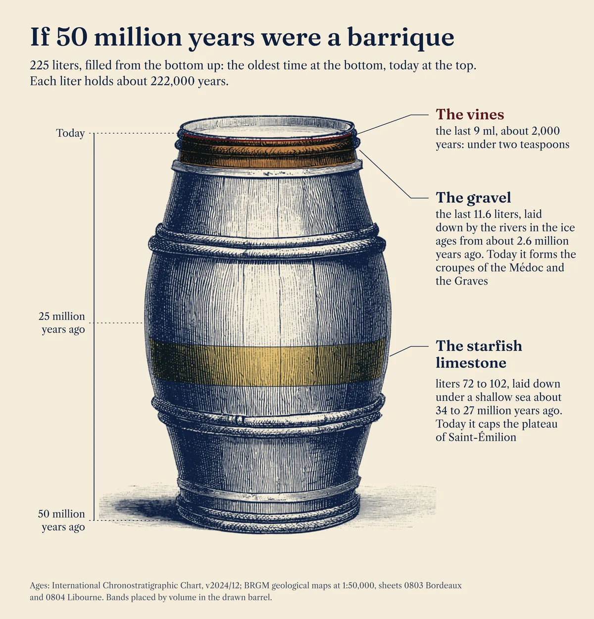
To hold those ages in mind, pour them into a barrique. The plateau’s limestone is in liters 72 to 102. Pauillac’s gravel is in the last 11.6.
Pauillac: from the croupe to the estuary
- West of Pauillac: older gravel terraces and cover: 21 to 28 m, from 0.0 to 1.1 km
- Croupe: ice age gravel: 11 to 28 m, from 1.1 to 2.1 km
- Narrow valley: the palus of the Chenal du Gaet: 4 to 11 m, from 2.1 to 2.5 km
- Croupe: ice age gravel: 6 to 21 m, from 2.5 to 3.9 km
- Palus and the estuary’s edge: 2 to 10 m, from 3.9 to 4.3 km
Colors: the geology at the surface: Ice age river terraces: sand, gravel, pebblesSlope wash and coverRiver and estuary deposits of today
Pauillac is gravel almost wall to wall: 88.0% of its delimited area lies on ice age river terraces. In the cold of the ice ages, great rivers, the ancestors of the Dordogne and the Gironde, carried sand, gravel and pebbles down from the Pyrenees and the Massif Central and spread them across the Médoc. Between Saint-Seurin-de-Cadourne and Pauillac the gravel is much coarser than elsewhere on the map sheet, rich in pebbles that average 6 to 8 centimeters across.
Toward the end of the ice ages, narrow valleys cut into that sheet of gravel; the croupes are the long, low rises between such valleys. The road north out of Pauillac crosses one, “a gravelly croupe of old alluvium that carries the vineyard of Pauillac,” in the words of the 1973 map.
Measured along a west to east line through the middle of the appellation, the land rises from 3.5 meters at the Chenal du Gaet to 20.6 meters on the last croupe, 550 meters on, and comes down to the estuary’s edge 1.4 kilometers later.
The maps disagree on the gravel’s age. BRGM’s harmonized map of the Gironde puts most of Pauillac’s on the high terraces of the older glaciation it calls “Günz”; the 1973 sheet had placed the same gravel later, between “Riss” and “Würm.” Both agree that rivers of the ice ages laid it down.
At the estuary’s edge the gravel gives way to the palus, the clay of the river marshes, 0.7% of the appellation. The 1973 notice records the mattes along this shore, marshland “drained by the Dutch” and given over to grass. The rest is slope wash and cover, 8.8%, Landes sand caught in hollows of the limestone, 1.2%, and older limestone and marl showing through here and there, 1.5%.
Gravel holds little water, and the vines go looking for it. In the great Médoc vineyards, Gérard Seguin of Bordeaux’s Institute of Oenology found roots as deep as 5 meters, often stopped only by the water table, drinking what the table leaves behind as it sinks through spring and summer. Young vines with shallow roots are the ones that suffer in a dry June and July (1975).
2 soils, 2 ways of growing a vine. Different, not better.
How I measured
Each appellation’s delimited area comes from INAO’s digitized parcel delimitation of October 12, 2026; the geology from BRGM’s harmonized 1:50,000 map of the Gironde (BD Charm-50). I merged each appellation’s parcels and measured the area on every geological unit, in the Lambert 93 projection. The units are grouped by age and rock as BRGM’s legend prints them; the codes are below. These figures are informative: the plans held at the town hall are the legal reference. The 2 cross-sections are measured: elevations from IGN’s RGE ALTI 5 m (2021), one point every 10 meters, along lines set by a fixed rule through the middle of each appellation, not chosen for the view, with the geology at the surface from the same BRGM map. They are drawn at the same scale, with heights stretched 20 times, and they show the surface only.
The units in each family
Saint-Émilion
| Code | Name as printed in the BRGM legend | Share |
|---|---|---|
| Slope wash and cover | 12.6% | |
| CFp | Formations superficielles | 4.6% |
| CF | Formations superficielles | 8.0% |
| River and estuary deposits of today | 3.0% | |
| Fy3-z | Alluvions subactuelles à actuelles indiféernéciées, Pré-boréal à actuel | 3.0% |
| Ice age river terraces: sand, gravel, pebbles | 43.7% | |
| Fy | Terrasses sous-flandriennes indiférenciées, Weichsélien - "Wurm" | 2.7% |
| Fxb3 | Basses terrasses (RD Garonne) - Terrasse d'Izon (type 6), Saalien - "Riss" | 13.2% |
| Fxb2 | Basses terrasses (RD Garonne) - Terrasse d'Izon (type 6), Saalien - "Riss" | 18.3% |
| Fxb1 | Basses terrasses (RD Garonne) - Terrasse d'Izon (type 6), Saalien - "Riss" | 6.5% |
| Fvb(D) | Hautes terrasses (RD Garonne) - Terrasse de Malleret inf. (type 2) indiférenciée, Ménapien-Bavélien - "Gunz" | 3.1% |
| Starfish limestone and marine marls | 12.8% | |
| g1-As | Calcaire à Astéries, Rupélien marin | 12.7% |
| g1-Ml | Marnes à Longirostris, Rupélien marin | under 0.1% |
| Lake limestones and clays | 2.3% | |
| g1-Cc | Formation du Calcaire de Castillon s.s., Rupélien basal continental | 2.3% |
| Molasses: sands and clays of old rivers and lakes | 25.6% | |
| g1a | Formation de Boisbreteau moy. et formation de la Garde, Rupélien inf. continental | 8.0% |
| e7 | Formation Boisbreteau inf., Priabonien sup. continental | 1.6% |
| e7-g1-A | Molasse du Fronsadais sup. à facies argileux dominant, Priabonien sup. à Rupélien basal continental | 3.4% |
| e7-g1-S | Molasse du Fronsadais sup. à facies sableux dominant, Priabonien sup. à Rupélien basal continental | 10.6% |
| e7c-A | Molasses du Fronsadais inf. à moy. (facies argileux dominant), Priabonien sup. continental | 1.7% |
| e6-7 | Argiles à Paléotherium, Bartonien sup. à Priabonien inf. continental | 0.5% |
Pauillac
| Code | Name as printed in the BRGM legend | Share |
|---|---|---|
| Slope wash and cover | 8.8% | |
| CFp | Formations superficielles | 8.8% |
| River and estuary deposits of today | 0.7% | |
| FMy3-z | Schorre actuel et fossile de l'Estuaire de la Gironde, Pré-boréal à actuel | 0.7% |
| Ice age river terraces: sand, gravel, pebbles | 88.0% | |
| Fvb(G) | Hautes terrasses (RG Garonne) - Terrasse de Martillac (type 2) indifférenciée et terrasse d'Arsac, Ménapien à Bavélien - "Gunz" | 73.7% |
| Fva(G) | Très hautes terrasses (RG Garonne) - Terrasse de Léognan (type 1) indifférenciée et terrasse de Listrac, Waal - "Donau-Günz" | 14.2% |
| Landes sand and the oldest river deposits | 1.2% | |
| SLk | Sables des Landes, Pléistocène indifférencié | 1.2% |
| Starfish limestone and marine marls | 0.7% | |
| g1-As | Calcaire à Astéries, Rupélien marin | 0.2% |
| g1-Ar | Calcaire à Archiacina, Rupélien marin | 0.5% |
| g1-Mb | Marnes de bel Air, Rupélien basal marin | under 0.1% |
| Lake limestones and clays | 0.1% | |
| g1-Ac | Formation de Castillon - Argiles Vertes de Castillon (et formation de la Bessède), Rupélien basal continental | under 0.1% |
| Older sea limestones and marls | 0.7% | |
| e7b-A | Groupe de Plassac - Faciès régréssif d'Artigues, faciès à Anomies, Priabonien moy. marin | under 0.1% |
| e7a-Ce | Groupe de Plassac - Calcaires de St Estephe, Priabonien inf. marin | 0.7% |
Sources
- INAO, Délimitation parcellaire des AOC viticoles, file of October 12, 2026, data.gouv.fr (Licence Ouverte).
- BRGM, BD Charm-50, harmonized geological map of the Gironde at 1:50,000, read October 15, 2026 (Licence Ouverte 2.0).
- BRGM, Notice explicative de la feuille Libourne à 1/50 000, 1995.
- BRGM, Notice explicative de la feuille Lesparre-Médoc, Forêt-du-Junca à 1/50 000, 1973.
- J. Duteau, “Contribution des réserves hydriques profondes du calcaire à Astéries compact à l’alimentation en eau de la vigne dans le Bordelais,” Agronomie 7, 1987, pages 859 to 865.
- G. Seguin, “Alimentation en eau de la vigne et composition chimique des moûts dans les grands crus du Médoc. Phénomènes de régulation,” Connaissance de la Vigne et du Vin, 1975.
- C. van Leeuwen and others, “Vine water status is a key factor in grape ripening and vintage quality for red Bordeaux wine. How can it be assessed for vineyard management purposes?” Journal International des Sciences de la Vigne et du Vin, 2009.
- C. van Leeuwen, J.-C. Baudet, J. Duteau, G. Seguin and P. Wilbert, “Les sols viticoles et leur répartition à Saint-Émilion, Pomerol et quelques autres communes du Libournais,” Connaissance de la Vigne et du Vin 23 (3), 1989.
- IGN, RGE ALTI 5 m, Gironde (D033), edition of April 19, 2021 (Licence Ouverte); profiles read along the transects of October 16, 2026.
- International Commission on Stratigraphy, International Chronostratigraphic Chart, v2024/12.
Test yourself on Bordeaux · Found an error? Corrections