3D
Terroir · Bordeaux in 3D
The Right Bank in 3D
The Right Bank: Libourne,
In 3D
This browser cannot open the block in 3D; the image and the list show the same map.
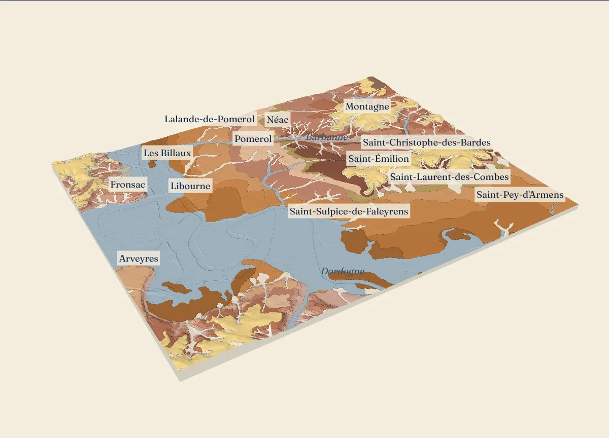
How IGN measured this relief: 59.5% aerial photos taken in winter, error under 70 cm; 39.6% airborne laser (LiDAR), error under 30 cm; 0.8% the older 25 m grid, error 2 to 8 m.
The formations of the geological map, from the largest area of the block to the smallest (19)
- Fy3-z Alluvions subactuelles à actuelles indiféernéciées (sic)River and estuary deposits of today; 24.2% of the block
- e7-g1-S Molasse du Fronsadais sup. à facies sableux dominantMolasses: sands and clays of old rivers and lakes; 12.4% of the block
- Fxb2 Basses terrasses (RD Garonne) - Terrasse d'Izon (type 6)Ice age river terraces: sand, gravel, pebbles; 10.1% of the block
- g1-As Calcaire à AstériesStarfish limestone and marine marls; 10.1% of the block
- Fxb3 Basses terrasses (RD Garonne) - Terrasse d'Izon (type 6)Ice age river terraces: sand, gravel, pebbles; 6.7% of the block
- CF Formations superficiellesSlope wash and cover; 6.7% of the block
- Fxb1 Basses terrasses (RD Garonne) - Terrasse d'Izon (type 6)Ice age river terraces: sand, gravel, pebbles; 5.4% of the block
- e7-g1-A Molasse du Fronsadais sup. à facies argileux dominantMolasses: sands and clays of old rivers and lakes; 4% of the block
- Fvb(D) Hautes terrasses (RD Garonne) - Terrasse de Malleret inf. (type 2) indiférenciéeIce age river terraces: sand, gravel, pebbles; 3.6% of the block
- Fy Terrasses sous-flandriennes indiférenciéesIce age river terraces: sand, gravel, pebbles; 3.5% of the block
- g1a Formation de Boisbreteau moy. et formation de la GardeMolasses: sands and clays of old rivers and lakes; 2.7% of the block
- CFp Formations superficiellesSlope wash and cover; 2.3% of the block
- g1-Cc Formation du Calcaire de Castillon s.s.Lake limestones and clays; 2.2% of the block
- e6-7 Argiles à PaléotheriumMolasses: sands and clays of old rivers and lakes; 1.9% of the block
- e7c-A Molasses du Fronsadais inf. à moy. (facies argileux dominant)Molasses: sands and clays of old rivers and lakes; 1.5% of the block
- e7 Formation Boisbreteau inf.Molasses: sands and clays of old rivers and lakes; 1.2% of the block
- Fwb(D) Moyennes terrasses - Terrasses du Malleret sup. indifférencié (type 3 à 5)Ice age river terraces: sand, gravel, pebbles; 1% of the block
- g2-A Molasse de l'Agenais sup. à faciès argileux dominantAgenais molasses: clays and sands above the limestone; 0.4% of the block
- E Formations superficiellesSlope wash and cover; 0.1% of the block
The layers under the surface, in The Descent:
Drag to turn, or use 2 fingers on a touch screen; pinch or use the mouse wheel to zoom. Tap a formation, a borehole or the list.
Sources: IGN, RGE ALTI 5 m, Gironde, edition of April 19, 2021, Licence Ouverte 2.0; BRGM, BD Charm-50, Gironde (GEO050K_HARM_033), Licence Ouverte 2.0; INRAE, Référentiel Régional Pédologique de la Gironde à 1/250 000 (Richer de Forges 2020, doi 10.15454/6BX5D7), Licence Ouverte Etalab 2.0; unit outlines from IGN’s Géoplateforme; INAO, délimitation parcellaire des AOC viticoles, file of October 12, 2026, Licence Ouverte; BRGM, Banque du sous-sol (BSS), Gironde export; logs as printed in the BRGM notices at 1/50,000; API Géo (geo.api.gouv.fr): town halls and commune names; IGN Géoplateforme (data.geopf.fr): SCAN EM 40K, BD ORTHO Historique, BD ORTHO; Licence Ouverte.
The height of each formation
The height above sea level of the land where each formation of BRGM’s geological map comes to the surface in this block, from IGN’s RGE ALTI heights read every 10 m.
| Code | Formation, as printed | Family | Share of the block | Median height | 8 tenths between |
|---|---|---|---|---|---|
| Fy3-z | Alluvions subactuelles à actuelles indiféernéciées (sic) | River and estuary deposits of today | 24.2% | 4 m | 2 to 6 m |
| e7-g1-S | Molasse du Fronsadais sup. à facies sableux dominant | Molasses: sands and clays of old rivers and lakes | 12.4% | 39 m | 23 to 49 m |
| Fxb2 | Basses terrasses (RD Garonne) - Terrasse d'Izon (type 6) | Ice age river terraces: sand, gravel, pebbles | 10.1% | 13 m | 8 to 15 m |
| g1-As | Calcaire à Astéries | Starfish limestone and marine marls | 10.1% | 74 m | 57 to 89 m |
| Fxb3 | Basses terrasses (RD Garonne) - Terrasse d'Izon (type 6) | Ice age river terraces: sand, gravel, pebbles | 6.7% | 9 m | 6 to 11 m |
| CF | Formations superficielles | Slope wash and cover | 6.7% | 33 m | 10 to 59 m |
| Fxb1 | Basses terrasses (RD Garonne) - Terrasse d'Izon (type 6) | Ice age river terraces: sand, gravel, pebbles | 5.4% | 18 m | 12 to 21 m |
| e7-g1-A | Molasse du Fronsadais sup. à facies argileux dominant | Molasses: sands and clays of old rivers and lakes | 4% | 55 m | 44 to 62 m |
| Fvb(D) | Hautes terrasses (RD Garonne) - Terrasse de Malleret inf. (type 2) indiférenciée | Ice age river terraces: sand, gravel, pebbles | 3.6% | 36 m | 31 to 39 m |
| Fy | Terrasses sous-flandriennes indiférenciées | Ice age river terraces: sand, gravel, pebbles | 3.5% | 5 m | 4 to 8 m |
| g1a | Formation de Boisbreteau moy. et formation de la Garde | Molasses: sands and clays of old rivers and lakes | 2.7% | 44 m | 39 to 56 m |
| CFp | Formations superficielles | Slope wash and cover | 2.3% | 31 m | 15 to 41 m |
| g1-Cc | Formation du Calcaire de Castillon s.s. | Lake limestones and clays | 2.2% | 59 m | 44 to 67 m |
| e6-7 | Argiles à Paléotherium | Molasses: sands and clays of old rivers and lakes | 1.9% | 16 m | 7 to 27 m |
| e7c-A | Molasses du Fronsadais inf. à moy. (facies argileux dominant) | Molasses: sands and clays of old rivers and lakes | 1.5% | 26 m | 16 to 37 m |
| e7 | Formation Boisbreteau inf. | Molasses: sands and clays of old rivers and lakes | 1.2% | 30 m | 25 to 35 m |
| Fwb(D) | Moyennes terrasses - Terrasses du Malleret sup. indifférencié (type 3 à 5) | Ice age river terraces: sand, gravel, pebbles | 1% | 26 m | 21 to 31 m |
| g2-A | Molasse de l'Agenais sup. à faciès argileux dominant | Agenais molasses: clays and sands above the limestone | 0.4% | 79 m | 77 to 82 m |
| E | Formations superficielles | Slope wash and cover | 0.1% | 4 m | 4 to 6 m |
The appellations
The AOC delimited areas inside the block (INAO parcel delimitation of October 12, 2026).
Saint-Émilion : 6,811 ha in the blockMontagne-Saint-Émilion : 2,203 ha in the blockLalande-de-Pomerol : 1,081 ha in the blockPomerol : 963 ha in the blockFronsac : 901 ha in the blockCanon-Fronsac : 319 ha in the block
The measured lines
The sections of the appellation pages that run through the block. In the 3D view, each one cuts the block.
Saint-Émilion , north to south, 6.9 km (the part inside the block)Pomerol , west to east, 7.1 kmCanon-Fronsac , west to east, 5.2 km (the part inside the block)Fronsac , west to east, 4.7 km (the part inside the block)Lalande-de-Pomerol , west to east, 8.2 kmMontagne-Saint-Émilion , west to east, 7.1 km (the part inside the block)Saint-Georges-Saint-Émilion , west to east, 4.2 km
Boreholes with a printed log
BRGM holds a verified log for 44 boreholes in this block.
The soils
The units of the soil map of the Gironde at 1/250,000, from the largest area of the block to the smallest. Each unit groups several soil types.
- UCS 54 GRANDS LITS MAJEURS DE L'ISLE, DE LA DORDOGNE ET DE LA GARONNE: 18.5%
- UCS 101 COMPLEXE LIMONO-SABLEUX SUR ARGILES, HYDROMORPHE, PLUS OU MOINS LESSIVE DU LIBOURNAIS: 11%
- UCS 96 SOLS SABLEUX BRUNIFIES DE SAINT-EMILION, SUR ALLUVIONS, DANS LE LIBOURNAIS: 10.7%
- UCS 99 SYSTEME DE TERRASSES, GENERALEMENT SABLEUX EN SURFACE MAIS POUVANT PRESENTER UN CONTRASTE TEXTURAL NET, HYDROMORPHE, DU LIBOURNAIS: 7.8%
- UCS 97 SOLS DE GRAVES DU LIBOURNAIS: 6.9%
- UCS 92 COMPLEXE CALCAIRE ET CALCIQUE SUR MOLASSE DU FRONSADAIS ET CALCAIRE A ASTERIES DU LIBOURNAIS: 6.8%
- UCS 33 SOLS SABLEUX BRUNIFIES CAILLOUTEUX DES TERRASSES DE LA DORDOGNE, DU LIBOURNAIS: 6.4%
- UCS 103 SYSTÈME DES SOLS SABLEUX DE LA MOYENNE TERRASSE DE LA VALLEE DE L'ISLE: 5%
- UCS 129 COMPLEXE DE SOLS LESSIVES DES PLATEAUX HYDROMORPHES, SUR MOLASSE DE L'AGENAIS SUR CALCAIRE A ASTERIES, DE L'ENTRE-DEUX-MERS ORIENTAL: 4.1%
- UCS -4 COURS D'EAU: 3.8%
- UCS 42 LIT MINEUR DE L'ISLE, DE LA DRONNE ET DE SES AFFLUENTS: 3.7%
- UCS -6 ZONE URBANISEE: 3.5%
- UCS 120 COMPLEXE HYDROMORPHE, A DOMINANTE LIMONEUSE, DES PLATEAUX ET REBORDS DE PLATEAUX, DU LANDAIS: 2.9%
- UCS 105 COTEAUX CALCAIRES DES VIGNOBLES DU LIBOURNAIS: 1.6%
- UCS 102 SOLS LIMONO-SABLEUX, HYDROMORPHES, BATTANTS, NON CALCAIRES DES VALLONS DU LIBOURNAIS: 1.6%
- UCS 98 SOLS SABLO-LIMONEUX, PROFONDS, NON CALCAIRES, CAILLOUTEUX, DU VIGNOBLE DE POMEROL: 1.5%
- UCS 94 COMPLEXE DES SOLS CALCAIRES ET LESSIVES SUR CALCAIRE A ASTÉRIES DES PLATEAUX ÉTROITS DU LIBOURNAIS: 1.5%
- UCS 123 PLATEAUX HYDROMORPHES, LESSIVES, DE L'ENTRE-DEUX-MERS OCCIDENTAL: 1.1%
- UCS 134 VERSANTS MOLASSIQUES GENERALEMENT NON HYDROMORPHES, DE L'ENTRE-DEUX-MERS SEPTENTRIONAL: 0.6%
The other blocks
Test yourself on Bordeaux · Found an error? Corrections