3D
Terroir · Bordeaux in 3D
Pauillac and Saint-Julien in 3D
In 3D
This browser cannot open the block in 3D; the image and the list show the same map.
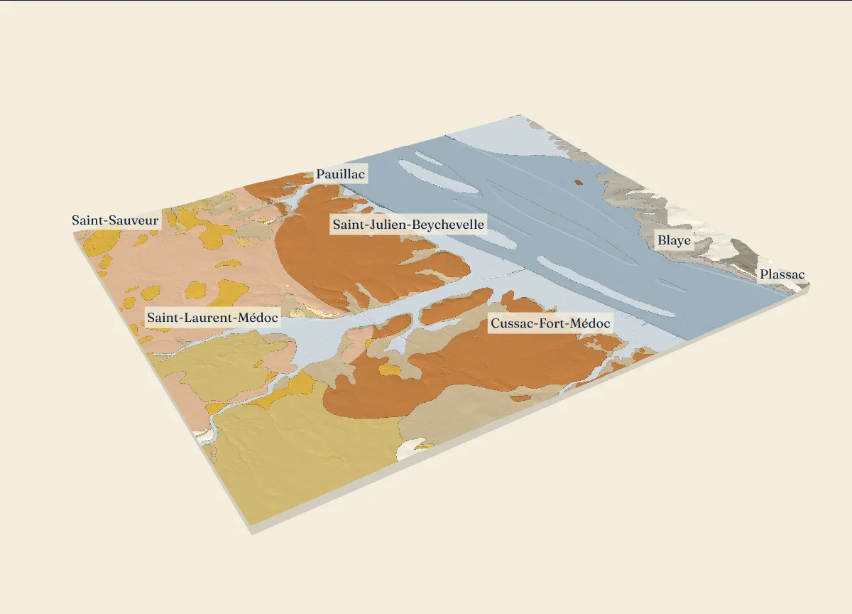
How IGN measured this relief: 99.8% airborne laser (LiDAR), error under 30 cm; 0.2% aerial photos taken in winter, error under 70 cm.
The formations of the geological map, from the largest area of the block to the smallest (25)
- Mz Slikke actuel de l'estuaire de la GirondeRiver and estuary deposits of today; 28% of the block
- Fvb(G) Hautes terrasses (RG Garonne) - Terrasse de Martillac (type 2) indifférenciée et terrasse d'ArsacIce age river terraces: sand, gravel, pebbles; 18.5% of the block
- FMy3-z Schorre actuel et fossile de l'Estuaire de la GirondeRiver and estuary deposits of today; 14.4% of the block
- Fva(G) Très hautes terrasses (RG Garonne) - Terrasse de Léognan (type 1) indifférenciée et terrasse de
Listrac Ice age river terraces: sand, gravel, pebbles; 12.5% of the block - SLk Sables des LandesLandes sand and the oldest river deposits; 8.1% of the block
- CFp Formations superficiellesSlope wash and cover; 8.1% of the block
- g1-As Calcaire à AstériesStarfish limestone and marine marls; 3.6% of the block
- e5-6(Bly3) Formation du calcaire de
Blaye (sommet)Older sea limestones and marls; 2.9% of the block - e7a-P Groupe de Plassac - Calcaire de PlassacLake limestones and clays; 1.8% of the block
- e6b-Ac Groupe de Plassac - Argiles à ostrea cucullarisOlder sea limestones and marls; 1% of the block
- e7b-Ms Groupe de Plassac - Marnes à sismondia occitana et ostrea bernonensis (supérieures)Older sea limestones and marls; 0.5% of the block
- Ft(Bn) Formation de BelinLandes sand and the oldest river deposits; 0.2% of the block
- FMz Schorre actuel de l'estuaire de la GirondeRiver and estuary deposits of today; 0.1% of the block
- g1-Ar Calcaire à ArchiacinaStarfish limestone and marine marls; 0.1% of the block
- g1-Ml Marnes à LongirostrisStarfish limestone and marine marls; 0.1% of the block
- e7b-G Groupe de Plassac - Grès à AnomiesOlder sea limestones and marls; under 0.1% of the block
- Fxb3 Basses terrasses (RD Garonne) - Terrasse d'Izon (type 6)Ice age river terraces: sand, gravel, pebbles; under 0.1% of the block
- e7-g1 Molasses du Fronsadais indifférenciéesMolasses: sands and clays of old rivers and lakes; under 0.1% of the block
- e7a-Ce Groupe de Plassac - Calcaires de St EstepheOlder sea limestones and marls; under 0.1% of the block
- e7b-A Groupe de Plassac - Faciès régréssif d'Artigues, faciès à AnomiesOlder sea limestones and marls; under 0.1% of the block
- g1-Mb Marnes de bel AirStarfish limestone and marine marls; under 0.1% of the block
- e5-6(Bly2) Formation du calcaire de
Blaye Older sea limestones and marls; under 0.1% of the block - g1-Ac Formation de Castillon - Argiles Vertes de Castillon (et formation de la Bessède)Lake limestones and clays; under 0.1% of the block
- e5-6(Bly1) Formation du calcaire de
Blaye (base)Older sea limestones and marls; under 0.1% of the block - Fva(D) Très hautes terrasses (RD Garonne) - Terrasse d'Artigues (type 1) indiférenciéeIce age river terraces: sand, gravel, pebbles; under 0.1% of the block
The layers under the surface, in The Descent:
Drag to turn, or use 2 fingers on a touch screen; pinch or use the mouse wheel to zoom. Tap a formation, a borehole or the list.
Sources: IGN, RGE ALTI 5 m, Gironde, edition of April 19, 2021, Licence Ouverte 2.0; BRGM, BD Charm-50, Gironde (GEO050K_HARM_033), Licence Ouverte 2.0; INRAE, Référentiel Régional Pédologique de la Gironde à 1/250 000 (Richer de Forges 2020, doi 10.15454/6BX5D7), Licence Ouverte Etalab 2.0; unit outlines from IGN’s Géoplateforme; INAO, délimitation parcellaire des AOC viticoles, file of October 12, 2026, Licence Ouverte; BRGM, Banque du sous-sol (BSS), Gironde export; logs as printed in the BRGM notices at 1/50,000; API Géo (geo.api.gouv.fr): town halls and commune names; IGN Géoplateforme (data.geopf.fr): SCAN EM 40K, BD ORTHO Historique, BD ORTHO; Licence Ouverte.
The height of each formation
The height above sea level of the land where each formation of BRGM’s geological map comes to the surface in this block, from IGN’s RGE ALTI heights read every 10 m.
| Code | Formation, as printed | Family | Share of the block | Median height | 8 tenths between |
|---|---|---|---|---|---|
| Mz | Slikke actuel de l'estuaire de la Gironde | River and estuary deposits of today | 28% | -2 m | -2 to 3 m |
| Fvb(G) | Hautes terrasses (RG Garonne) - Terrasse de Martillac (type 2) indifférenciée et terrasse d'Arsac | Ice age river terraces: sand, gravel, pebbles | 18.5% | 18 m | 9 to 23 m |
| FMy3-z | Schorre actuel et fossile de l'Estuaire de la Gironde | River and estuary deposits of today | 14.4% | 3 m | 1 to 4 m |
| Fva(G) | Très hautes terrasses (RG Garonne) - Terrasse de Léognan (type 1) indifférenciée et terrasse de | Ice age river terraces: sand, gravel, pebbles | 12.5% | 26 m | 13 to 31 m |
| SLk | Sables des Landes | Landes sand and the oldest river deposits | 8.1% | 18 m | 11 to 27 m |
| CFp | Formations superficielles | Slope wash and cover | 8.1% | 11 m | 4 to 24 m |
| g1-As | Calcaire à Astéries | Starfish limestone and marine marls | 3.6% | 26 m | 11 to 30 m |
| e5-6(Bly3) | Formation du calcaire de | Older sea limestones and marls | 2.9% | 9 m | 4 to 16 m |
| e7a-P | Groupe de Plassac - Calcaire de Plassac | Lake limestones and clays | 1.8% | 25 m | 17 to 31 m |
| e6b-Ac | Groupe de Plassac - Argiles à ostrea cucullaris | Older sea limestones and marls | 1% | 19 m | 13 to 27 m |
| e7b-Ms | Groupe de Plassac - Marnes à sismondia occitana et ostrea bernonensis (supérieures) | Older sea limestones and marls | 0.5% | 27 m | 21 to 38 m |
| Ft(Bn) | Formation de Belin | Landes sand and the oldest river deposits | 0.2% | 31 m | 12 to 35 m |
| FMz | Schorre actuel de l'estuaire de la Gironde | River and estuary deposits of today | 0.1% | 3 m | 1 to 4 m |
| g1-Ar | Calcaire à Archiacina | Starfish limestone and marine marls | 0.1% | 28 m | 24 to 32 m |
| g1-Ml | Marnes à Longirostris | Starfish limestone and marine marls | 0.1% | 11 m | 7 to 15 m |
The appellations
The AOC delimited areas inside the block (INAO parcel delimitation of October 12, 2026).
Haut-Médoc : 4,841 ha in the blockPauillac : 1,250 ha in the blockSaint-Julien : 1,048 ha in the blockListrac-Médoc : 107 ha in the block
The measured lines
The sections of the appellation pages that run through the block. In the 3D view, each one cuts the block.
Pauillac , west to east, 14.3 km (the part inside the block)Saint-Julien , west to east, 7.1 km
Boreholes with a printed log
BRGM holds a verified log for 24 boreholes in this block.
The boreholes in this block whose log BRGM printed, layer by layer, in the notices of its 1/50,000 geological maps. Each log is given as printed.
07791X0004/F2 ·
- Quaternary: 0 to 3 m (Quaternaire)
- middle Eocene: 3 to 80 m (Éocène moyen)
- early Eocene: 80 to 179 m (Éocène inférieur)
- upper Senonian, Late Cretaceous: 179 to 185.3 m (Sénonien supérieur)
BRGM, notice 0779, p. 41
07791X0002/F · Plassac; top of the hole at 3.5 m above sea level
- Quaternary: 0 to 5.3 m (Quaternaire)
- middle Eocene: 5.3 to 89 m (Éocène moyen)
BRGM, notice 0779, p. 41
07791X0008/PZEM12 · Saint-Genès-de-
- Quaternary: 0 to 3.8 m (Quaternaire)
- middle Eocene: 3.8 to 115.4 m (Éocène moyen)
- early Eocene: 115.4 to 120.2 m (Éocène inférieur)
BRGM, notice 0779, p. 42
The soils
The units of the soil map of the Gironde at 1/250,000, from the largest area of the block to the smallest. Each unit groups several soil types.
- UCS -4 COURS D'EAU: 21.5%
- UCS 109 SOLS PROFONDS, SABLEUX, SUR GRAVES DU MEDOC: 18.1%
- UCS 62 LANDE HUMIDE: 10%
- UCS 61 LANDE MESOPHILE: 8.2%
- UCS 14 PALUS DE L'ESTUAIRE DE LA GIRONDE: 7.5%
- UCS 73 SURFACE PLANE SABLEUSE, ACIDE, HYDROMORPHE DES LANDES DE GASCOGNE SUR LES GRAVIERS DU MEDOC: 5.4%
- UCS 9 SOLS DES ILES DE LA GIRONDE: 3.7%
- UCS 12 MATTES DE L'ESTUAIRE DE LA GIRONDE: 3.6%
- UCS 110 SOLS ISSUS DU RECOUVREMENT DES GRAVES DU MEDOC PAR DU SABLE DES LANDES: 3.4%
- UCS 108 COMPLEXE SABLEUX SUR ARGILE A GRAVIERS GROSSIERS DU MEDOC: 3.1%
- UCS 77 SOLS FAIBLEMENT LESSIVES PLUS OU MOINS HYDROMORPHES DU BLAYAIS ET DU BOURGEAIS: 2.8%
- UCS 15 PALUS HUMIDES DE L'ESTUAIRE DE LA GIRONDE: 2.7%
- UCS 76 SOLS CALCAIRES PLUS OU MOINS MINCES SUR CALCAIRES DU BLAYAIS ET DU BOURGEAIS: 2.6%
- UCS 53 VALLONS HYDROMORPHES, SANS ELEMENTS GROSSIERS, DE L'ENTRE-DEUX-MERS, DU BLAYAIS ET DU BOURGEAIS: 2.2%
- UCS -6 ZONE URBANISEE: 2.1%
- UCS 16 DEPRESSIONS TOURBEUSES DE L'ESTUAIRE DE LA GIRONDE: 1.9%
- UCS 72 SURFACE PLANE SABLEUSE, ACIDE, DES LANDES DE GASCOGNE SUR LES GRAVIERS DE LA REGION DES GRAVES: 0.7%
The other blocks
Test yourself on Bordeaux · Found an error? Corrections